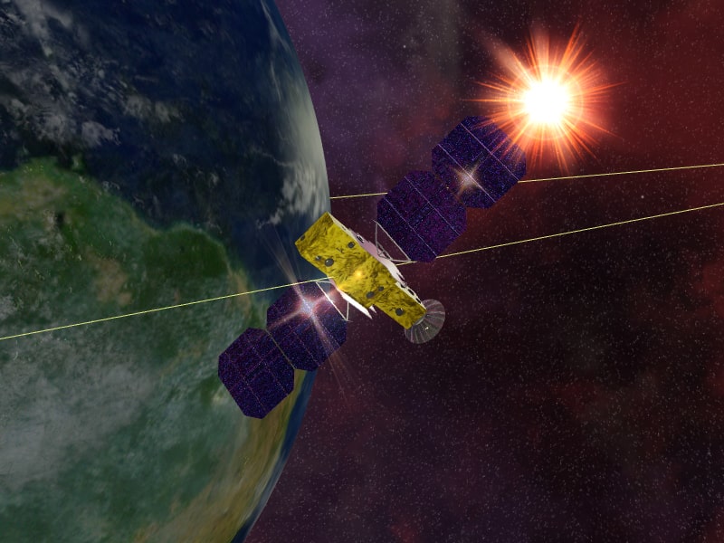
Satellites are pivotal to modern society, providing essential services that underpin many aspects of daily life, scientific research, and global security. One of the most significant roles of satellites is in global communication. They enable the transmission of television, radio, and internet services, particularly to remote and rural areas where terrestrial infrastructure is lacking. This global connectivity supports education, healthcare, and economic development by providing access to information and services that would otherwise be unavailable. Additionally, satellites facilitate reliable and secure communication channels for governments and military operations, enhancing national security.
In the realm of navigation and positioning, satellites are indispensable. The Global Positioning System (GPS) and other GNSS (Global Navigation Satellite Systems) like GLONASS, Galileo, and BeiDou offer precise location and timing information critical for various applications. These include everyday activities like driving and outdoor sports, as well as complex operations in aviation, maritime navigation, and logistics. The accuracy and reliability of satellite-based navigation systems have revolutionized transportation, making it safer and more efficient. Moreover, these systems are vital for emergency services, search and rescue operations, and disaster response, enabling quick and accurate location tracking and coordination.
Satellite Data
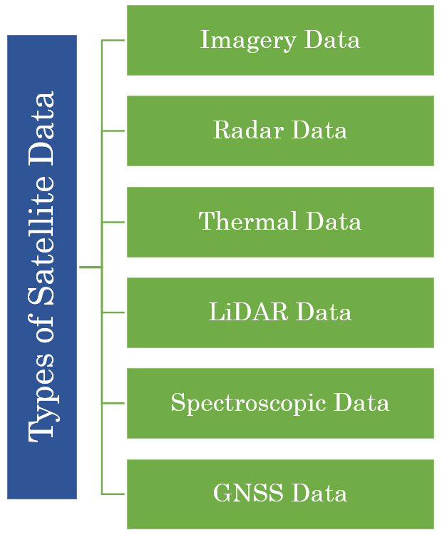
Satellite data refers to information collected by artificial satellites orbiting the Earth. These satellites are equipped with various sensors and instruments that capture a wide range of data about the Earth's surface, atmosphere, and other environmental parameters. The data collected by satellites is used in numerous applications, including weather forecasting, environmental monitoring, disaster management, and scientific research.
Optical Imagery
Optical imagery satellites capture images of the Earth's surface using visible, infrared, and near-infrared wavelengths. These satellites, such as Landsat, Sentinel-2, and commercial satellites like those from DigitalGlobe, provide detailed photographs that can be used for various applications including urban planning, agriculture, and environmental monitoring. Optical imagery helps in observing land use patterns, vegetation cover, and changes over time. The data can be analyzed to monitor deforestation, urban sprawl, and natural disasters. However, optical imagery is limited by weather conditions and daylight availability, as clouds and darkness can obstruct the view of the Earth's surface.
Radar Data
Radar data, particularly from Synthetic Aperture Radar (SAR) satellites like Sentinel-1 and RADARSAT, uses microwave radar to create detailed images of the Earth's surface. SAR is advantageous because it can penetrate clouds and operate day and night, providing consistent data regardless of weather conditions. This makes radar data invaluable for monitoring areas with frequent cloud cover and for applications requiring regular, reliable data such as oil spill detection, earthquake assessment, and land subsidence monitoring. Interferometric SAR (InSAR) further enhances radar data by measuring ground deformation and topography changes over time, which is critical for geophysical and infrastructure monitoring.
Thermal Data
Thermal satellites capture the heat emitted from the Earth's surface, providing data on temperature variations. This type of data is essential for applications such as monitoring volcanic activity, detecting wildfires, and studying urban heat islands. Satellites like MODIS and Landsat capture thermal infrared data, which can reveal temperature anomalies and track heat distribution patterns. Thermal data is also used in climate studies to monitor sea surface temperatures and assess their impact on weather and climate systems. The ability to detect and analyze heat signatures makes thermal data a crucial tool for environmental monitoring and disaster management.
LiDAR Data
Light Detection and Ranging (LiDAR) technology uses laser pulses to create high-resolution 3D maps of the Earth's surface. LiDAR satellites measure the time it takes for the laser pulses to return after hitting the ground, producing detailed topographical maps. This data is particularly useful for applications requiring precise elevation measurements, such as flood modeling, forest canopy analysis, and infrastructure planning. LiDAR's high spatial resolution allows for detailed mapping of vegetation structure, urban areas, and terrain features, making it an essential tool for forestry management, urban planning, and environmental conservation.
Spectroscopic Data
Spectroscopic satellites measure the spectrum of light reflected or emitted from the Earth's surface, providing detailed information about the chemical composition of materials. This type of data is critical for identifying minerals, assessing soil properties, and monitoring water quality. Hyperspectral imaging, which captures data in many narrow spectral bands, allows for precise identification of materials based on their spectral signatures. Applications of spectroscopic data include mineral exploration, agricultural monitoring, and pollution detection. By analyzing the spectral characteristics of different surfaces, scientists can gain insights into the composition and health of ecosystems and natural resources.
GNSS Data
Global Navigation Satellite System (GNSS) satellites, including GPS, GLONASS, Galileo, and BeiDou, provide positioning, navigation, and timing (PNT) information. This data is essential for navigation in aviation, maritime, and terrestrial transportation, enabling accurate location tracking and route planning. GNSS data supports various applications such as geolocation services, mapping, and precision agriculture. The high accuracy and global coverage of GNSS systems make them indispensable for emergency response, search and rescue operations, and scientific research requiring precise geospatial data. GNSS also plays a crucial role in synchronizing time for communication networks, financial systems, and power grids.

Satellite Data Preprocessing
Preprocessing satellite data is fraught with challenges primarily due to the complexity and scale of the data involved. The vast volumes of data generated by satellite sensors require significant storage and computational resources for effective processing. Handling such large datasets efficiently is a major logistical challenge, especially when dealing with high-resolution imagery or time-series data that demand substantial memory and processing power. Additionally, satellite data often comes in varied formats like GeoTIFF, HDF, and NetCDF, necessitating specialized tools for reading, converting, and standardizing these formats. This heterogeneity complicates data integration and necessitates a robust preprocessing pipeline to ensure compatibility and accuracy.
Another significant challenge is the inherent noise and anomalies present in satellite data. Factors like sensor errors, atmospheric conditions, and environmental interferences introduce noise and artifacts that can distort the data. Techniques like radiometric and geometric corrections are essential to calibrate the data, ensuring it accurately represents the observed phenomena. Moreover, issues like cloud cover, shadows, and atmospheric scattering further complicate preprocessing, requiring sophisticated algorithms for cloud masking and atmospheric correction. The data also needs to be georeferenced accurately, aligning it with geographic coordinates, which can be complex given the diverse spatial resolutions and projections used by different satellites. Additionally, addressing missing data through interpolation or multi-temporal analysis is crucial for creating comprehensive and usable datasets. These preprocessing steps are vital to transform raw satellite data into reliable and analyzable forms, essential for various applications such as environmental monitoring, disaster management, and scientific research.
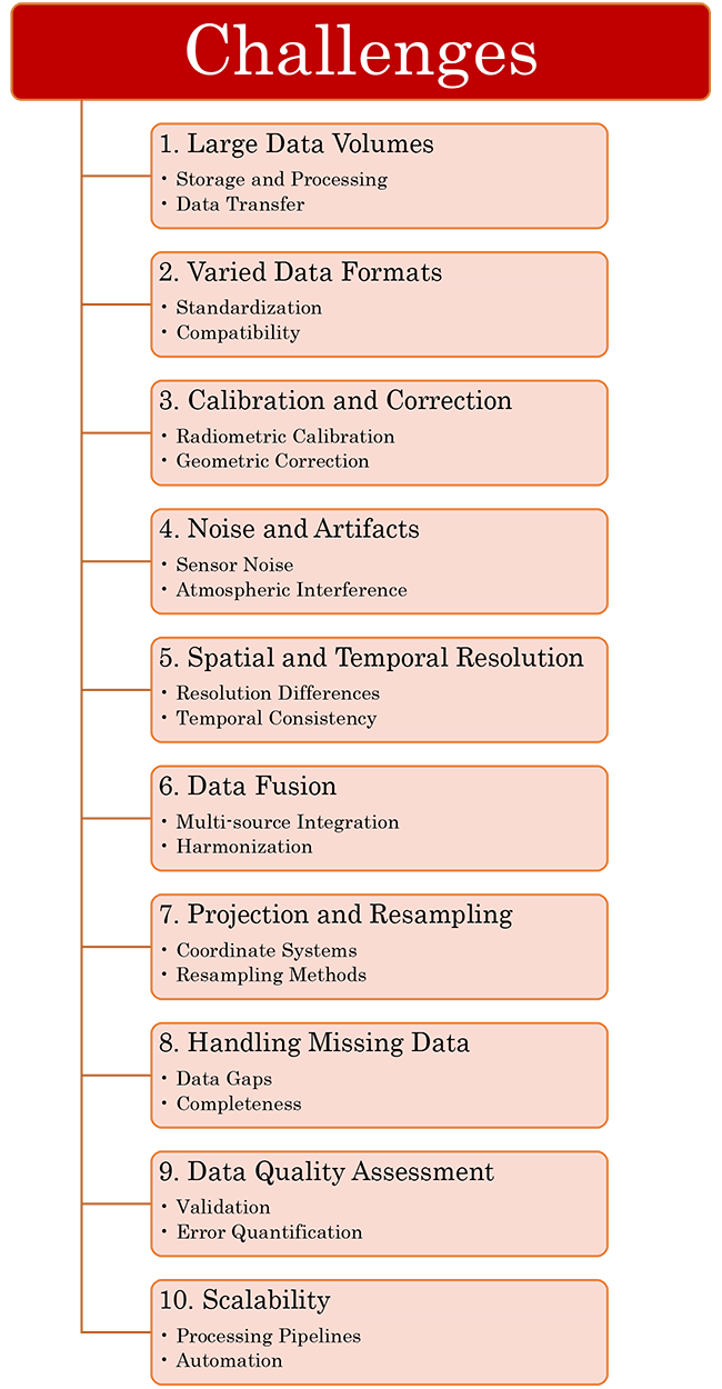
Preprocessing satellite data involves several key challenges due to the unique characteristics and complexities of the data. The main challenges can be described in many categories. Addressing these challenges requires a combination of advanced data processing techniques, specialized software tools, and robust computational infrastructure. Effective preprocessing is essential to transform raw satellite data into reliable and actionable information for various applications.
Large Data Volume
One of the primary challenges of satellite data preprocessing is managing the large volumes of data generated by satellite sensors. These sensors continuously capture high-resolution imagery and other data types, resulting in massive datasets that require substantial storage capacity and processing power. Efficiently storing, transferring, and processing these large datasets is logistically demanding, often necessitating powerful computational infrastructure and sophisticated data management strategies. This challenge is compounded by the need for rapid data processing, especially for applications requiring near-real-time analysis, such as weather forecasting and disaster response. Ensuring that these large volumes of data can be processed and analyzed efficiently without compromising accuracy is critical for leveraging the full potential of satellite data.
Varied Data Formats
Varied data formats present a significant challenge in satellite data preprocessing due to the diversity in how data is collected and stored by different satellites and sensors. Satellite data can come in numerous formats, such as GeoTIFF, HDF, NetCDF, and proprietary formats specific to particular satellite missions. Each format has its own structure, metadata conventions, and compatibility requirements, making it complex to integrate and standardize the data for analysis. Preprocessing must involve converting these varied formats into a unified structure, ensuring that all datasets are compatible and can be accurately compared or combined. This process often requires specialized tools and software, and any discrepancies or errors in conversion can lead to significant data quality issues, hindering further analysis and application.
Calibration and Correction
Calibration and correction are critical challenges in satellite data preprocessing due to the need to adjust raw satellite data to accurately reflect the observed phenomena. Radiometric calibration involves correcting sensor-specific biases and ensuring that the pixel values accurately represent the Earth's surface reflectance or emitted radiation. Geometric correction aligns satellite images with geographic coordinates, correcting distortions caused by the sensor's perspective, the Earth's curvature, and its rotation. Additionally, atmospheric correction is necessary to remove distortions caused by the atmosphere's interference, such as scattering and absorption of light. These corrections are essential to produce reliable and precise data, as inaccuracies in calibration can lead to errors in subsequent analyses and applications, such as land cover mapping, environmental monitoring, and disaster management.
Noise and Artifacts
Noise and artifacts in satellite data preprocessing pose significant challenges due to various factors that can distort the captured data. Sensor noise, resulting from electronic interference and inherent sensor imperfections, can degrade the quality of the imagery, making it difficult to extract accurate information. Additionally, environmental factors such as atmospheric particles, clouds, and shadows can introduce artifacts that obscure or alter the true surface reflectance or radiance. Addressing these issues requires sophisticated filtering and correction techniques to remove or mitigate the noise and artifacts, ensuring the data is clean and reliable. Effective preprocessing to handle these distortions is crucial for accurate analysis and interpretation in applications like environmental monitoring, land use classification, and disaster response.

Spatial and Temporal Resolution
Spatial and temporal resolution are critical challenges in satellite data preprocessing due to the varying levels of detail and frequency at which data is captured by different satellites. Spatial resolution refers to the size of the smallest object that can be resolved in an image, with high-resolution data providing detailed imagery but often covering smaller areas, while low-resolution data covers larger areas but with less detail. Temporal resolution refers to the frequency at which a satellite revisits and captures data for the same location, affecting the ability to monitor changes over time. Managing these differences is challenging when integrating data from multiple sources or satellites, as it requires harmonizing the spatial and temporal characteristics to ensure consistency and accuracy. This is particularly important for time-series analysis and applications that rely on both detailed and frequently updated data, such as climate change monitoring, agricultural assessments, and urban planning.
Data Fusion
Data fusion in satellite data preprocessing is a significant challenge because it involves integrating data from multiple satellites and sensors, each with different spatial resolutions, spectral bands, and temporal frequencies. The goal of data fusion is to combine these diverse datasets to create a more comprehensive and informative representation of the observed phenomena. However, this process is complex due to the need to reconcile differences in data formats, coordinate systems, and inherent measurement characteristics. Ensuring that the fused data is accurate and reliable requires sophisticated algorithms and techniques to align, resample, and calibrate the data from various sources. Successful data fusion enhances the overall quality and utility of satellite data, enabling more precise and detailed analysis for applications such as environmental monitoring, disaster management, and land use classification. However, the technical challenges and computational demands of achieving effective data fusion make it a critical and demanding aspect of satellite data preprocessing.
Projection and Resampling
Projection and resampling are crucial challenges in satellite data preprocessing due to the need to transform data from the satellite's sensor geometry to a standard geographic coordinate system. Satellites capture data in various projections and spatial resolutions depending on their orbits and sensor configurations. To integrate and analyze these datasets effectively, they must be converted to a common projection and resampled to a consistent spatial resolution while preserving the integrity and accuracy of the data. This process ensures that data from different sources or satellites can be compared, combined, and analyzed seamlessly. Choosing appropriate resampling methods, such as nearest-neighbor, bilinear, or cubic convolution, is essential to minimize distortion and information loss during this transformation. Addressing projection and resampling challenges is critical for accurate spatial analysis, such as mapping, land cover classification, and environmental modeling, where precise spatial referencing is essential.
Handling Missing Data
Handling missing data is a significant challenge in satellite data preprocessing due to various factors that can lead to gaps in the data. These gaps may occur due to sensor malfunctions, cloud cover, atmospheric interference, or limitations in satellite coverage. Addressing missing data requires employing sophisticated techniques such as interpolation, where missing values are estimated based on surrounding observations or temporal trends. Alternatively, multi-temporal analysis can be used to fill gaps by integrating data from different time points when the area of interest was not obstructed. It is crucial to handle missing data effectively to ensure the completeness and reliability of datasets used for subsequent analyses and applications such as land use monitoring, climate studies, and disaster assessment. Poor handling of missing data can introduce biases and inaccuracies, impacting the quality and validity of results derived from satellite data.
Data Quality Assessment
Data quality assessment is a critical challenge in satellite data preprocessing because it involves ensuring the accuracy, reliability, and consistency of the processed data before it can be used for analysis or decision-making. Satellite data may suffer from various sources of errors including sensor malfunctions, atmospheric interference, geometric distortions, and noise. Therefore, rigorous validation and quality control processes are essential to assess the quality of the data. This includes comparing satellite observations with ground truth data or other independent sources to verify accuracy, evaluating the precision of measurements, and identifying and correcting any systematic biases. Data quality assessment also involves quantifying uncertainties and errors in the data to understand the limitations and reliability of the information provided by satellite sensors. Ultimately, ensuring high-quality data is fundamental to the credibility and usefulness of satellite-based applications in fields such as environmental monitoring, disaster management, agriculture, and scientific research.
Scalability
Scalability is a significant challenge in satellite data preprocessing because of the enormous volumes of data continuously generated by satellite sensors and the increasing demand for timely processing and analysis. The scalability challenge involves designing preprocessing workflows and infrastructure that can efficiently handle large-scale data processing tasks. This includes deploying robust computational resources capable of managing and processing massive datasets in a timely manner. Moreover, as satellite missions continue to evolve with higher resolution sensors and increased temporal frequency, the scalability of preprocessing systems must adapt to accommodate these advancements without sacrificing efficiency or accuracy. Implementing scalable solutions often requires leveraging cloud computing platforms, distributed computing frameworks, and parallel processing techniques to optimize resource utilization and ensure timely delivery of processed data for applications such as real-time monitoring, disaster response, and scientific research.
Conclusion
Dealing with challenges in satellite data preprocessing involves employing a combination of advanced techniques and algorithms. Geometric distortions can be corrected using geometric modeling and resampling methods, while atmospheric interference can be mitigated through atmospheric correction algorithms that account for different atmospheric conditions. Cloud cover can be addressed using cloud masking techniques to identify and remove or interpolate cloudy pixels. Calibration processes ensure that satellite sensor data are accurately converted into physical units, considering factors like sensor characteristics and radiometric calibration. Additionally, employing data fusion approaches can integrate multiple satellite datasets or sources to enhance spatial and temporal resolution, providing more comprehensive and reliable information for various applications such as environmental monitoring, disaster management, and urban planning.
The benefit of effective data preprocessing is that it improves the quality, usability, and reliability of the data for subsequent analysis and decision-making. By addressing issues such as noise, missing values, outliers, and inconsistencies, preprocessing ensures that the data is cleaner and more accurate. This leads to more robust and reliable analytical results, reduces the likelihood of errors in interpretations and conclusions, and enhances the overall efficiency of data-driven processes and applications. Effective preprocessing also enables better data integration from diverse sources, facilitates easier modeling and algorithm development, and ultimately supports more informed decision-making across various domains such as healthcare, finance, environmental monitoring, and beyond.
References
-
Big Data Preprocessing Phase in Engendering Quality Data
Bina Kotiyal, Heman Pathak
Machine Learning, Advances in Computing, Renewable Energy and Communication (2021)
-
A review: Data pre-processing and data augmentation techniques
Kiran Maharana, Surajit Mondal, Bhushankumar Nemade
Global Transitions Proceedings (2022)
-
Noise regularization removes correlation artifacts in single-cell RNA-seq data preprocessing
Ruoyu Zhang, Gurinder S. Atwal, Wei Keat Lim
Patterns (2021)
-
Big Data Preprocessing
Julián Luengo, Diego García-Gil, Sergio Ramírez-Gallego, Salvador García, Francisco Herrera
(2020)
-
Survey:Time-series data preprocessing: A survey and an empirical analysis
Amal Tawakuli, Bastian Havers, Vincenzo Gulisano, Daniel Kaiser, Thomas Engel
Journal of Engineering Research (2024)


